Hull's Trace North Huron River Corduroy Segment
Historic Photo from NRHP Filing
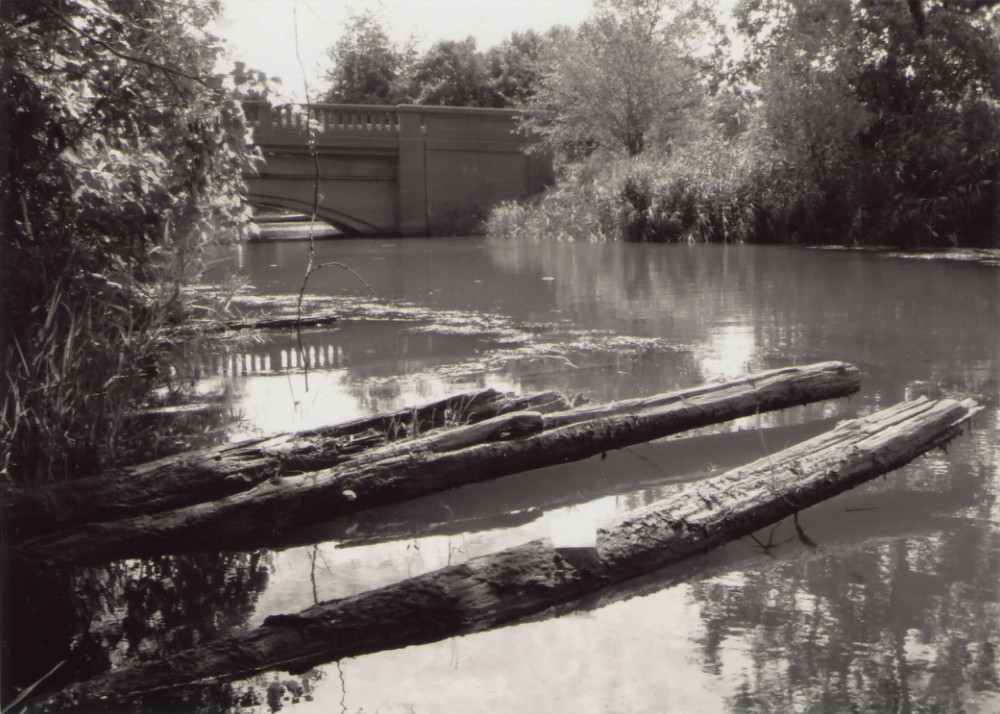
A880840 1/6 <Michisa..001.jpg> 07/07/10 Photograph 1 of 6 MI_Wayne County_Hulls Trace_0001
National Register of Historic Places Filing
The corduroy road segment beneath Jefferson Avenue just north of the Huron River meets national register criterion A at the national level as a remnant- the only one thus far identified- of 'Hull's Trace' or Road, a 200-mile long military road hastily built in the summer of 1812 by troops under the command of American General William Hull to convey his army with its military supplies from southwestern Ohio north to Detroit. Hull's march to garrison and resupply Detroit was to be followed by an attack on Fort Malden, the British stronghold downstream across the Detroit River from Detroit, part of a broader American plan developed at the beginning of the War of 1812 for a three-pronged invasion of British-held Canada. The corduroy road segment, built by Hull's forces in late June or early July 1812, played a role in major events in the War of 1812 in the Old Northwest. It carried Hull's supply wagons on their way to Detroit on the 4th of July, 1812.
It likely carried the British force, with its equipment, that defeated the Americans in the second Battle of Frenchtown January 22, 1813, from and back to Fort Malden. It also likely carried Col. Richard M. Johnson's force of mounted Kentucky riflemen, with their baggage wagons and artillery, on their way from Fort Meigs in Ohio to Detroit in late September 1813 to support Gen.
William Henry Harrison's attack on the British in western Ontario in the wake of Commodore Oliver H. Perry's defeat of the British fleet controlling Lake Erie on September 10. The road segment meets national register criterion C as an intact example of corduroy road construction that may be unique in its overall length and meets criterion D for its potential to provide important information about corduroy road construction, about the pre-deposition landscape in the area, the structure's use during the War of 1812, and the improvement and evolution of the feature into a modern roadway.
Physical Description
The feature consists of a partially buried remnant of corduroy road, constructed by setting unsquared logs closely together at a right angle to the axis of the roadway. The exposed portion of the feature emerges from the northwest side of the embankment supporting a modern roadway, and extends in a discontinuous sequence over a distance of approximately 380 meters. The logs appear to be resting directly on the soil substrate, although a single log has been observed in the position of a lengthwise stringer supporting several crosswise logs at their outer ends. The logs are at or near water level, as the roadway and its embankment border a canal. Fluctuations in the water level of nearby Lake Erie cause variations in the submersion or exposure of the logs.
NRHP Ref# 10001022 • Data from National Park Service • Content available under CC BY-SA 4.0
Historic Photos
(6)Sourced from the National Register of Historic Places filing
Hull's Trace North Huron River Corduroy Segment—A880840 1/6 <Michisa..001.jpg> 07/07/10 Photograph 1 of 6 MI_Wayne County_Hulls Trace_0001
Public Domain (Michigan Filing)
Building Details
- Address
- 36000 W Jefferson Ave, Brownstown Township
- National Register
- Listed
- Ref# 10001022