Virginia Park Historic District
Historic Photo from NRHP Filing
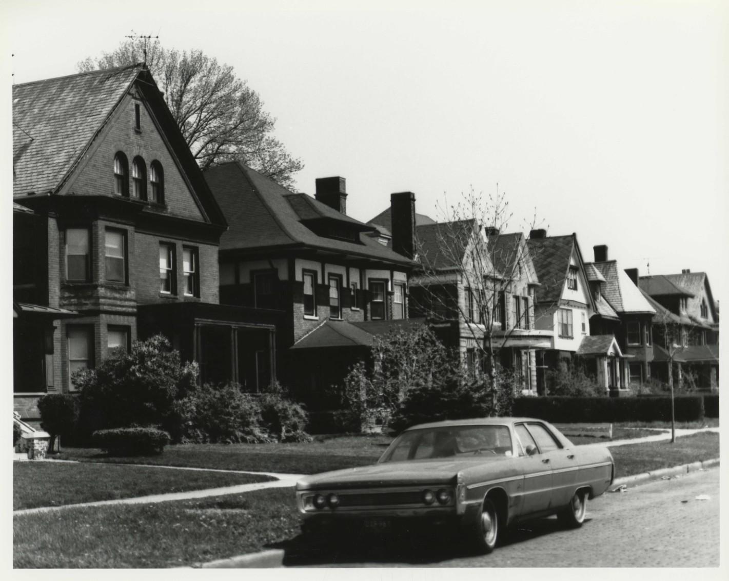
VIRGINIA PARK HISTORIC DISTRICT Detroit, Wayne County, Michigan PHOTO: Historic Designation Advisory Board DATE: 1981 NEG: Historic Designation Advisory Board City-County Bldg.,, Detroit, Mich. VIEW: Looking east along north side PHOTO: #1 of 12 Virginia Park: Street view Detroit, Mi. Ctaken (1981)
National Register of Historic Places Filing
The Virginia Park Historic District is significant as an example of a well preserved late nineteenth to early twentieth-century suburban residential neighborhood whose ultimate development and form was planned in advance. The neighborhood was conceived as an upper-middle-class enclave and its appearance was predetermined by building requirements filed with the original subdivision plat. As a whole, Virginia Park is architecturally significant for its noteworthy late nineteenth to early twentieth-century homes, which exemplify a wide range of contemporary architectural styles. Many of them are significant as the work of important, turn-of-the-century Detroit architects.
The Virginia Park Historic District was laid out in 1893 and developed by John W. Leggett, realtor, Frank E. Snow, developer, and Joseph C. Hough, advertising agent.
Originally named Virginia Avenue, the street was paved in brick from Woodward Avenue to Third Avenue. Ninety-two lots were platted and each was given a name--such as Tanglewood, Thistledown, Sorrento, Mayview, and Shamrock--in the original subdivision plat. The developers filed with the original subdivision plat a number of building restrictions. The original plat maps of Peerless Additions 1 through 3, prepared by Mason L.
Brown, surveyor and engineer, in 1893, show a building set-back line located twenty-five feet from the street. Other restrictions placed on lots in this area were that the property be used for residential purposes only; no building not of brick or stone be constructed; no dwelling cost less than $5,000; no double houses be erected; and no more than one house on each fifty-foot lot be erected. These restrictions ensured the development of an attractive, upper-middle-class neighborhood. The first eleven houses arose on Virginia Avenue in 1895 and by 1908 more than two dozen elegant suburban homes lined the street.
The quiet boulevard attracted a mix of businessmen and professionals: George E. Moody, founder of a large investments firm; Albert T. Knowlson, president of A. T.
Knowlson Co.; assistant city engineer George A. Robinson; Jacob Cotner, Jr., of Sprague Publishing Co.; John M. Welch, a prominent real estate broker; Percy Ashton, manager of American Phonograph Co.; George Pottle, architect; and several other brokers, contractors, lawyers and merchants. Concern was raised as early as 1910 about the rapidly increasing commercialization of Woodward Avenue.
Homeowners became concerned about the diminishing residential character of Detroit's most prominent thoroughfare and the negative impact this commercialization would have on adjoining property values. In response to this, a group of property owners on Virginia Avenue formed the Virginia Avenue Improvement Association with the goal of re-landscaping the entrances to the subdivision. In keeping with the park-like nature of the planned entrances, the name was changed from Virginia Avenue to Virginia Park. Property owners donated between $500 to $2,500 to finance the plan.
The Detroit Free Press of March 26, 1911 announced: Unique beyond anything yet devised in this city and strikingly original in the method of development is the plan by which property owners along Virginia Avenue propose to increase the natural beauty of their street and perpetuate it as a park-like thoroughfare, exclusively devoted to fine residences.
Physical Description
The Virginia Park Historic District is a rectangular three-block long district fronting on both sides of the narrow, two-lane Virginia Park. Containing fifty-eight structures, the district is composed mainly of late nineteenth to early twentieth-century residences. These brick and stone structures, which housed early twentieth century business people and professionals, were built on a uniform setback line in a variety of styles which were popular at the turn of the century. Virginia Park is reached off Woodward Avenue, Detroit's major artery, through a park-like entrance way.
The district is located approximately three miles northwest from Detroit's central business district. The three-block area, which runs east-west along Virginia Park, a two-lane avenue, is bounded by Woodward Avenue on the east, Lodge Freeway on the west and the rear property lines of buildings fronting on Virginia Park on the north and south. The district is on the northern boundary of the General Motors-sponsored New Center Commons redevelopment project. Slightly later residential areas including the Boston-Edison Historic District and the Arden Park-East Boston Boulevard Historic District are located to the north.
Virginia Park was platted in a grid fashion and consists of three plats, each one a linear strip one block long and one lot deep. Public alleys ten feet in width run behind the lots parallel to Virginia Park. The building lots are fifty feet wide and 163 feet deep. The district is entered from Woodward through a Colonial style entranceway which consists of a low, eighty-foot, brick wall.
It is divided into three sections--a broad, central one and shorter, sidewalk-pierced, side ones--by a pair of narrow driveway entrances from Woodward which merge inside the wall to form Virginia Park. The wall/entranceway is located at the Woodward Avenue street line and behind it originally existed a park-like space. Plans are being made to landscape and refurbish this east gateway which has survived intact. The west gateway, similar in design, along with 240 feet of Virginia Park frontage, were destroyed when the Lodge Freeway was built.
Uniformity is achieved in the district by building restrictions which were filed with the original subdivision plat. These restrictions included a required twenty-five-foot setback line, all buildings to be constructed of brick or stone, and no dwelling to cost less than $5,000. No double houses were to be erected and no more than one house on each fifty foot lot. Of Virginia Park's fifty-seven structures, fifty-four contribute to the historic character of the district.
Fifty-one of these are currently in residential use, two are used as offices and one as a rest home. The residential structures in the proposed district were constructed between 1895 and 1915. The oldest homes, which date from the last five years of the nineteenth century, are located in the first block of Virginia Park between Woodward Avenue and Second Boulevard. Those constructed between 1900 and 1915 are between Second Boulevard and the Lodge Freeway.
The structures are generally two-and-one-half stories in height, of red or orange brick with stone and wood trim, roofed with slate, tile, or shingles and often containing open porches. The diversity of styles includes Colonial Revival, Neo-Georgian, Tudor, Arts and Crafts-Inspired and Bungalow. The condition of the structures is generally fair. However, upgrading is currently taking place through private efforts and at least six buildings are being renovated through the New Center Commons Redevelopment Project.
Structures which do not contribute to the historic character of the district are a modern apartment building on two lots at 650 Virginia Park and a hospital at 801-831 Virginia Park. An office building which fronts on Second Boulevard (613 Virginia Park) is also not included.
Architect/Builder
See below
NRHP Ref# 82000557 • Data from National Park Service • Content available under CC BY-SA 4.0
Historic Photos
(12)Sourced from the National Register of Historic Places filing
Virginia Park Historic District—VIRGINIA PARK HISTORIC DISTRICT Detroit, Wayne County, Michigan PHOTO: Historic Designation Advisory Board DATE: 1981 NEG: Historic Designation Advisory Board City-County Bldg.,, Detroit, Mich. VIEW: Looking east along north side PHOTO: #1 of 12 Virginia Park: Street view Detroit, Mi. Ctaken (1981)
Public Domain (Michigan Filing)
From Wikipedia
The Virginia Park Historic District is located on the north side of New Center, an area in Detroit, Michigan, along both sides of Virginia Park Street from Woodward Avenue to the John C. Lodge Freeway access road. The district was listed on the National Register of Historic Places in 1982. The Virginia Park Historic District is an example of a well–preserved late nineteenth to early twentieth century residential community. The residences are testimonials to the wealth of early Virginia Park residents, as the area was conceived as an upper-middle class enclave. Many homes were completed by prominent Detroit architects, and display a diversity of architectural styles.
History The district was laid out in 1893 by developed by John W. Leggett, Frank E. Snow, and Joseph C. Hough. Ninety-two lots were platted and each given a name (such as Tanglewood, Thisteldown, and Sorrento) in the original plat. The developers placed a number of restrictions on the area to ensure an attractive community. This quiet boulevard attracted a mix of businessmen and professionals. The first houses were constructed in 1895. By 1908 more than two dozen houses had been constructed in the district. By 1910, homeowners became concerned about the effect of the increasing commercialization of Woodward Avenue on property values, and they formed the Virginia Avenue Improvement Association. The association proposed to re-landscape the subdivision, and it developed an attractive entrance to the community. The neighborhood continued to thrive during the 1920s. It suffered in the 1930s from the Great Depression, the effects of which continued through the 1940s. By the 1950s and 1960s, many of the houses had absentee landlords, or were divided into rooming houses. The Algiers Motel, at one time located at the corner of Virginia Park and Woodward, was the scene of an incident of police brutality during the 1967 Detroit riot where three men were killed and others were beaten. In 1979, General Motors announced its plan to renovate the area north of its World Headquarters. This fostered rehabilitation in the Virginia Park district. The Algiers Motel was demolished in 1979, and replaced with a park space. The Virginia Park Historic District is considered to mark the northern boundary of the New Center area of Detroit. In 2022, one of Detroit's last remaining brick streets, built in 1907 in Virginia Park, began a $2 million rehabilitation. Stretching three blocks along Virginia Park Street between Woodward Ave, and the Lodge Freeway. As many as 20,000 age-appropriate Nelsonville block pavers have been assembled for the repair work.
Description The Virginia Park District was platted as a series of lots 50 feet wide and 163 feet deep. The original restrictions in the neighborhood ensured a uniformity in the streetscape. All buildings are constructed of brick or stone, and have the same setback from the street. All are single family houses, with no more than one house on each fifty foot lot. At the time of its historic designation, the district included 57 structures, all but three of which contribute to the historic character of neighborhood. Non-contributing structures included an apartment building at 650 Virginia Park, an office building at 613 Virginia Park, and a hospital (demolished in 2014) at 801-831 Virginia Park. Fifty-one of the contributing structures were used as homes, two as offices and one as a rest home. The residences were constructed between 1895 and 1915, with the older structures placed closer to Woodward, and newer ones, in general, farther westward.
Education The area is zoned to Detroit Public Schools. All residents are zoned to Thirkell Elementary School, Hutchins Middle School, and Northwestern High School.
Images
Content available under CC BY-SA 4.0
Building Details
- Architect
- See below
- Address
- Both sides of Virgia Park From Woodward Ave. to John Lodge Service Dr., Detroit
- National Register
- Listed
- Ref# 82000557